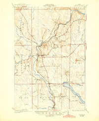
1934 Map of Ashland
USGS Topo · Published 1945About this map
The Aroostook River and the Bangor and Aroostook railroad corridor define the industrial and social life of this Northern Maine region during the 1930s. The settlement of Ashland sits at a central crossroads, supported by outlying communities like Sheridan and Masardis. This survey, compiled in part from Air Corps aerial photographs, reveals a landscape deeply connected to timber and transport. Numerous small schoolhouses, including Old Stetson Sch and Nashville Sch, are scattered throughout the townships, reflecting a decentralized rural population. The presence of Nowland Mill and logging infrastructure like the Tote Road near No 6 Camp underscores the importance of the lumber industry. To the southeast, the expansive Squapan Lake and the smaller Mud Pond break the forest, while family-named landmarks like McClellan Sch on Castle Hill provide valuable points of interest for genealogical research.
Find a feature on this map
57 named features on this map. Tap any name to fly to it.
Don’t see what you’re looking for? This feature index may not catch every label — zoom into the map to look around manually.
Map Details
Editions of this 1934 Ashland Map
3 editions found
Other maps of this area

1928 · Winterville
USGS Topo · 1:48,000

1929 · Portage
USGS Topo · 1:62,500

1929 · Caribou
USGS Topo · 1:48,000

1930 · Greenlaw
USGS Topo · 1:48,000

1931 · Ashland
USGS Topo · 1:48,000

1931 · Portage
USGS Topo · 1:62,500

1931 · Winterville
USGS Topo · 1:62,500

1932 · Caribou
USGS Topo · 1:62,500

1933 · Greenlaw
USGS Topo · 1:62,500

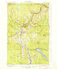
1934 · Ashland
USGS Topo · 1:62,500