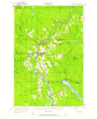
1953 Map of Ashland
USGS Topo · Published 1959About this map
The Aroostook River winds through the heart of this North Woods landscape, serving as the primary corridor for the central town of Ashland and the nearby mill community of Sheridan. The early 1950s infrastructure is dominated by the Bangor and Aroostook railroad, which follows the river valley and supports essential shipping points like Trafton Siding and Nowland Siding. To the south, Squapan Lake and the high elevations of Sterling Ridge and Grove Hill define a terrain deeply involved in the timber economy, evidenced by numerous networks of logging trails such as Old Tote Road. Genealogists will find valuable localized landmarks including the Winslow Cem and Robinson Cem, alongside rural social centers like the Rockwell Sch. This survey documents a transitional era where traditional river-and-rail transport still anchored these Aroostook County townships before modern highway expansion.
Find a feature on this map
59 named features on this map. Tap any name to fly to it.
Don’t see what you’re looking for? This feature index may not catch every label — zoom into the map to look around manually.
Map Details
Editions of this 1953 Ashland Map
4 editions found

Other maps of this area

1928 · Winterville
USGS Topo · 1:48,000

1929 · Portage
USGS Topo · 1:62,500

1929 · Caribou
USGS Topo · 1:48,000

1930 · Greenlaw
USGS Topo · 1:48,000

1931 · Ashland
USGS Topo · 1:48,000

1931 · Portage
USGS Topo · 1:62,500

1931 · Winterville
USGS Topo · 1:62,500

1932 · Caribou
USGS Topo · 1:62,500

1933 · Greenlaw
USGS Topo · 1:62,500

1934 · Ashland
USGS Topo · 1:62,500