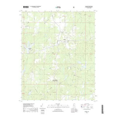
2018 Map of Ashland
USGS Topo · Published 2018About this map
Ashland serves as the seat of Benton County, appearing here as a crossroads community amidst the undulating hills of North Mississippi. The landscape is characterized by a mix of agricultural bottoms and forested tracts, with a significant portion of the southern area protected within the Holly Springs National Forest. For genealogists, the map is remarkably dense with family and community landmarks, including Bethlehem Cem, Ayers Cem, and Bogard Cem, alongside the centralized Ashland Cem. The residential development at Snow Lake Shores surrounds the waters of Snow Lake, contrasting with the more rural drainage basins of Robinson Bottom and the Tippah River. This 2018 survey also identifies infrastructure such as the John Farese Airpark and numerous country roads like Tubby Bottom Rd and Carter Flat Rd, which provide a detailed framework of the modern rural infrastructure.
Find a feature on this map
118 named features on this map. Tap any name to fly to it.
Don’t see what you’re looking for? This feature index may not catch every label — zoom into the map to look around manually.
Map Details
Editions of this 2018 Ashland Map
This is the sole edition of this map. No revisions or reprints were ever made.
Other maps of this area

1944 · Potts Camp
USGS Topo · 1:62,500

1945 · Potts Camp
USGS Topo · 1:62,500

1950 · Ashland
USGS Topo · 1:62,500

1953 · Holly Springs
USGS Topo · 1:62,500

1955 · Blue Mountain
USGS Topo · 1:62,500

1956 · Tupelo
USGS Topo · 1:250,000

1958 · Tupelo
USGS Topo · 1:250,000

1964 · Holly Springs SE
USGS Topo · 1:24,000
1965 · Lamar
USGS Topo · 1:24,000
1969 · Holly Springs
USGS Topo · 1:62,500