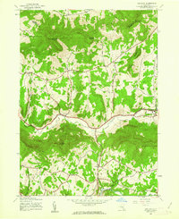
1945 Map of Ashland
USGS Topo · Published 1963About this map
Batavia Kill winds through the central valley of this northern Catskills region, anchoring a series of small agricultural and residential hubs during the mid-1940s. The settlement at Ashland serves as a primary local center, while higher elevations are defined by prominent peaks like Huntersfield Mountain and Ashland Pinnacle. The map reveals a landscape managed for both utility and preservation, with significant portions falling within the Catskill Park boundary.
Find a feature on this map
36 named features on this map. Tap any name to fly to it.
Don’t see what you’re looking for? This feature index may not catch every label — zoom into the map to look around manually.
Map Details
Editions of this 1945 Ashland Map
3 editions found
Other maps of this area

1892 · Kaaterskill
USGS Topo · 1:62,500

1893 · Kaaterskill
USGS Topo · 1:62,500

1893 · Durham
USGS Topo · 1:62,500

1894 · Kaaterskill
USGS Topo · 1:62,500

1894 · Durham
USGS Topo · 1:62,500

1899 · Kaaterskill
USGS Topo · 1:62,500

1900 · Phoenicia
USGS Topo · 1:62,500

1901 · Gilboa
USGS Topo · 1:62,500

1903 · Gilboa
USGS Topo · 1:62,500

1903 · Phoenicia
USGS Topo · 1:62,500