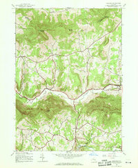
1945 Map of Ashland
USGS Topo · Published 1969About this map
Catskill Park defines the southern portion of this landscape, where the valley floor of the Batavia Kill serves as the primary corridor for settlement and transit. The hamlets of Ashland and Windham are situated along this waterway, surrounded by high-elevation terrain including Huntersfield Mountain, Ashland Pinnacle, and Richmond Mountain. The map reveals a distribution of family and community spaces characteristic of mid-century Greene County, with numerous small burial grounds such as Ashland Cem, Jewett Cem, and North Settlement Cem situated near local roads. To the south, across Patterson Ridge, the terrain descends into the East Kill valley toward West Jewett and Beecher Corners. The proximity of landmarks like The Knob and Tower Mountain to small schoolhouses like School No 3 and School No 6 illustrates a dispersed rural life centered on the local hollows and ridges of the northern Catskills.
Find a feature on this map
37 named features on this map. Tap any name to fly to it.
Don’t see what you’re looking for? This feature index may not catch every label — zoom into the map to look around manually.
Map Details
Editions of this 1945 Ashland Map
3 editions found
Other maps of this area

1892 · Kaaterskill
USGS Topo · 1:62,500

1893 · Kaaterskill
USGS Topo · 1:62,500

1893 · Durham
USGS Topo · 1:62,500

1894 · Kaaterskill
USGS Topo · 1:62,500

1894 · Durham
USGS Topo · 1:62,500

1899 · Kaaterskill
USGS Topo · 1:62,500

1900 · Phoenicia
USGS Topo · 1:62,500

1901 · Gilboa
USGS Topo · 1:62,500

1903 · Gilboa
USGS Topo · 1:62,500

1903 · Phoenicia
USGS Topo · 1:62,500