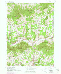
1945 Map of Ashland
USGS Topo · Published 1980About this map
The Batavia Kill valley serves as the central artery for this portion of the northern Catskills, where the settlement of Ashland sits along N. Y. 23. This 1945 landscape, based on field surveys from the mid-1940s with later 1970s revisions, illustrates a transition from traditional upland farming to protected forest lands within Catskill Park. The geography is defined by high peaks like Huntersfield Mountain and Richmond Mountain, which wall in narrow agricultural valleys. Traces of early 20th-century rural life are visible in the locations of School No 2 and small hamlets like West Settlement and North Settlement. To the south, the East Kill drainage highlights the township of Jewett, where West Jewett and Beecher Corners represent the quiet, scattered nature of these high-elevation communities before the expansion of modern mountain recreation.
Find a feature on this map
35 named features on this map. Tap any name to fly to it.
Don’t see what you’re looking for? This feature index may not catch every label — zoom into the map to look around manually.
Map Details
Editions of this 1945 Ashland Map
3 editions found
Other maps of this area

1892 · Kaaterskill
USGS Topo · 1:62,500

1893 · Kaaterskill
USGS Topo · 1:62,500

1893 · Durham
USGS Topo · 1:62,500

1894 · Kaaterskill
USGS Topo · 1:62,500

1894 · Durham
USGS Topo · 1:62,500

1899 · Kaaterskill
USGS Topo · 1:62,500

1900 · Phoenicia
USGS Topo · 1:62,500

1901 · Gilboa
USGS Topo · 1:62,500

1903 · Gilboa
USGS Topo · 1:62,500

1903 · Phoenicia
USGS Topo · 1:62,500