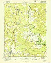
1951 Map of Ashland
USGS Topo · Published 1951About this map
Ashland serves as the primary hub of this Virginia interior at the midpoint of the century, defined by the concentrated layout of Randolph-Macon College and the north-south transit corridor of the Richmond Fredericksburg and Potomac railroad. To the north, Doswell functions as a critical junction where the north-south line intersects with the Chesapeake and Ohio, supporting local industry evidenced by a Sawmill and the Excelsior Mill.
Find a feature on this map
33 named features on this map. Tap any name to fly to it.
Don’t see what you’re looking for? This feature index may not catch every label — zoom into the map to look around manually.
Map Details
Editions of this 1951 Ashland Map
This is the sole edition of this map. No revisions or reprints were ever made.
Other maps of this area

1890 · Goochland
USGS Topo · 1:125,000

1892 · Goochland
USGS Topo · 1:125,000

1894 · Richmond
USGS Topo · 1:62,500

1895 · Richmond
USGS Topo · 1:62,500

1918 · Doswell
USGS Topo · 1:62,500

1936 · Glen Allen
USGS Topo · 1:24,000
1938 · Studley
USGS Topo · 1:31,680

1938 · Yellow Tavern
USGS Topo · 1:31,680

1941 · Glen Allen
USGS Topo · 1:31,680
1943 · Hanover Academy
USGS Topo · 1:31,680