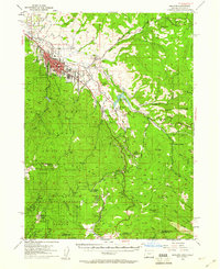
1954 Map of Ashland
USGS Topo · Published 1960About this map
The town of Ashland serves as the focal point of this mid-century survey, showing the residential and institutional layout including Southern Oregon College and the landmark Lithia Park. The landscape transition from the Rogue River Valley into the mountains is marked by the presence of Emigrant Reservoir and a series of smaller settlements and stops such as Mistletoe and Klamath Junction. The infrastructure of the era is clearly defined by the Southern Pacific RR and the Pacific Highway, which wind through the foothills toward the Oregon California state line.
Find a feature on this map
74 named features on this map. Tap any name to fly to it.
Don’t see what you’re looking for? This feature index may not catch every label — zoom into the map to look around manually.
Map Details
Editions of this 1954 Ashland Map
3 editions found

Other maps of this area

1886 · Shasta
USGS Topo · 1:250,000

1891 · Ashland
USGS Topo · 1:250,000

1893 · Ashland
USGS Topo · 1:250,000

1894 · Shasta
USGS Topo · 1:250,000

1897 · Ashland
USGS Topo · 1:250,000

1922 · Shasta Valley Sheet No 15
USGS Topo · 1:24,000

1932 · Yreka
USGS Topo · 1:96,000

1934 · Macdoel
USGS Topo · 1:96,000

1938 · Medford
USGS Topo · 1:125,000

1939 · Yreka
USGS Topo · 1:125,000