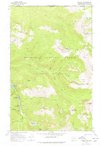
1969 Map of Ashnola Mtn
USGS Topo · Published 1978About this map
The Pasayten Wilderness of Okanogan County, just south of the Canadian border, is defined by its network of historical trails and high mountain basins as they existed in the late 1960s. High-altitude hydrology is the central theme of this terrain, anchored by the Hidden Lakes chain, including Big Hidden Lake, Middle Hidden Lake, and First Hidden Lake. The East Fork Pasayten River and Lost River drain the high peaks, with many tributaries like Peeve Creek and Quartz Creek flowing through narrow valleys. Human presence is marked by a complex system of pack trails, such as the Boundary Pack Trail, which provided access for forestry and back-country travel before modern road expansion. High landmarks like Ashnola Mountain and Bunker Hill overlook a landscape punctuated by remote points of interest, including a lone Shelter near Cougar Lake and the high Park Pass at the northern boundary.
Find a feature on this map
48 named features on this map. Tap any name to fly to it.
Don’t see what you’re looking for? This feature index may not catch every label — zoom into the map to look around manually.
Map Details
Editions of this 1969 Ashnola Mtn Map
2 editions found
Other maps of this area

1920 · Slate Pass
USGS Topo · 1:125,000

1955 · Concrete
USGS Topo · 1:250,000

1958 · Concrete
USGS Topo · 1:250,000

1962 · Concrete
USGS Topo · 1:250,000

1969 · Lost Peak
USGS Topo · 1:24,000
1969 · Ashnola Mtn
USGS Topo · 1:24,000

1969 · Tatoosh Buttes
USGS Topo · 1:24,000

1969 · Billy Goat Mtn
USGS Topo · 1:24,000

1969 · Ashnola Pass
USGS Topo · 1:24,000
1969 · Mount Lago
USGS Topo · 1:24,000