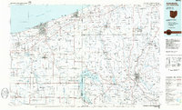
1986 Map of Ashtabula
USGS Topo · Published 1986About this map
The industrial and natural landscape of the Ohio-Pennsylvania border is documented here in the mid-1980s, anchored by the port city of Ashtabula on Lake Erie. This survey provides a comprehensive view of the transportation corridors that defined the region's economy, including the routes of the Conrail, Norfolk And Western, and Bessemer And Lake Erie railroads. Moving inland from the lakefront, the map transitions into a network of agricultural townships and significant conservation areas such as Pymatuning State Park, which surrounds the massive Pymatuning Reservoir.
Find a feature on this map
90 named features on this map. Tap any name to fly to it.
Don’t see what you’re looking for? This feature index may not catch every label — zoom into the map to look around manually.
Map Details
Editions of this 1986 Ashtabula Map
2 editions found
Other maps of this area

1899 · Erie
USGS Topo · 1:62,500

1900 · Girard
USGS Topo · 1:62,500

1900 · Erie
USGS Topo · 1:62,500

1900 · Fairview
USGS Topo · 1:62,500

1904 · Chardon
USGS Topo · 1:62,500

1905 · Andover
USGS Topo · 1:48,000

1905 · Ashtabula
USGS Topo · 1:62,500

1905 · Perry
USGS Topo · 1:62,500

1905 · Bristolville
USGS Topo · 1:62,500

1905 · Garrettsville
USGS Topo · 1:62,500