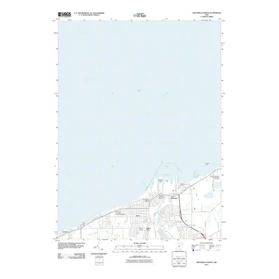
2010 Map of Ashtabula North
USGS Topo · Published 2010About this map
The Ashtabula River mouth and the bustling industrial shoreline of Lake Erie dominate this 2010 topographic record of northern Ohio. The map illustrates a landscape shaped by maritime commerce and higher education, centered on the Harbor district and the Kent State University Ashtabula Campus. The infrastructure of the Great Lakes shipping industry is highly detailed, featuring the Ashtabula Buffalo Dock, Union Dock, and the prominent Ashtabula Light guarding the harbor entrance.
Find a feature on this map
25 named features on this map. Tap any name to fly to it.
Don’t see what you’re looking for? This feature index may not catch every label — zoom into the map to look around manually.
Map Details
Editions of this 2010 Ashtabula North Map
This is the sole edition of this map. No revisions or reprints were ever made.
Other maps of this area

1905 · Ashtabula
USGS Topo · 1:62,500

1906 · Conneaut
USGS Topo · 1:62,500

1950 · Cleveland
USGS Topo · 1:250,000

1950 · Erie
USGS Topo · 1:250,000

1956 · Cleveland
USGS Topo · 1:250,000

1959 · Erie
USGS Topo · 1:250,000
1960 · North Kingsville
USGS Topo · 1:24,000
1960 · Gageville
USGS Topo · 1:24,000

1960 · Ashtabula South
USGS Topo · 1:24,000
1960 · Ashtabula North
USGS Topo · 1:24,000