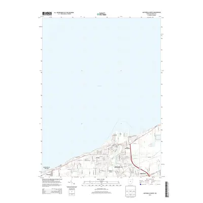
2013 Map of Ashtabula North
USGS Topo · Published 2013About this map
Lake Erie defines the northern reaches of this Ohio coastal survey, where the industrial and maritime heritage of Ashtabula meets the residential growth of the early 21st century. The map highlights the significant dock infrastructure at the mouth of the Ashtabula River, including the Ashtabula Buffalo Dock and Union Dock, which have long anchored the local economy. These commercial hubs are connected to the city via the West-Fifth Street Bridge, while the surrounding neighborhoods of Harbor and East Ashtabula show a dense grid of residential streets.
Find a feature on this map
87 named features on this map. Tap any name to fly to it.
Don’t see what you’re looking for? This feature index may not catch every label — zoom into the map to look around manually.
Map Details
Editions of this 2013 Ashtabula North Map
This is the sole edition of this map. No revisions or reprints were ever made.
Other maps of this area

1905 · Ashtabula
USGS Topo · 1:62,500

1906 · Conneaut
USGS Topo · 1:62,500

1950 · Cleveland
USGS Topo · 1:250,000

1950 · Erie
USGS Topo · 1:250,000

1956 · Cleveland
USGS Topo · 1:250,000

1959 · Erie
USGS Topo · 1:250,000
1960 · North Kingsville
USGS Topo · 1:24,000
1960 · Gageville
USGS Topo · 1:24,000

1960 · Ashtabula South
USGS Topo · 1:24,000
1960 · Ashtabula North
USGS Topo · 1:24,000