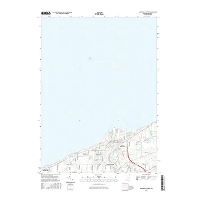
2016 Map of Ashtabula North
USGS Topo · Published 2016About this map
Lake Erie defines the northern extent of this shoreline survey, where the Ashtabula River meets the industrial and maritime infrastructure of the Harbor district. This map documents the modern layout of Ashtabula and its surrounding communities, such as East Ashtabula and Edgewood, showing the dense grid of residential streets like W 9th St and E 21st St that transition into the academic grounds of the Kent State Univ Ashtabula Campus. The infrastructure connecting these neighborhoods is clearly detailed, including the West Fifth Street Bridge spanning the river and the route of Lake Rd W along the coast. Smaller waterways such as Fields Brook and Red Brook weave through the landscape, providing a look at the local drainage and topography near Saint Josephs Cem.
Find a feature on this map
37 named features on this map. Tap any name to fly to it.
Don’t see what you’re looking for? This feature index may not catch every label — zoom into the map to look around manually.
Map Details
Editions of this 2016 Ashtabula North Map
This is the sole edition of this map. No revisions or reprints were ever made.
Other maps of this area

1905 · Ashtabula
USGS Topo · 1:62,500

1906 · Conneaut
USGS Topo · 1:62,500

1950 · Cleveland
USGS Topo · 1:250,000

1950 · Erie
USGS Topo · 1:250,000

1956 · Cleveland
USGS Topo · 1:250,000

1959 · Erie
USGS Topo · 1:250,000
1960 · North Kingsville
USGS Topo · 1:24,000
1960 · Gageville
USGS Topo · 1:24,000

1960 · Ashtabula South
USGS Topo · 1:24,000
1960 · Ashtabula North
USGS Topo · 1:24,000