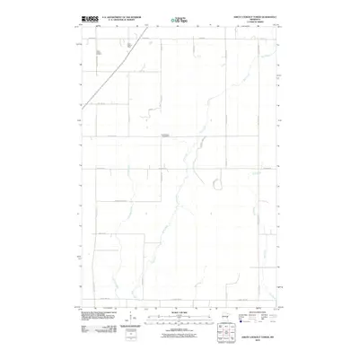
2010 Map of Askov Lookout Tower
USGS Topo · Published 2010About this map
Askov Lookout Tower stands as a prominent navigation point in this portion of Pine County, overlooking a landscape defined by a dense network of tributaries including Sand Creek, Partridge Creek, and Wolf Creek. The local infrastructure follows a systematic grid, yet the naming conventions of roads like Rutabaga Rd and Pickeral Creek Rd reflect the agricultural and natural character of the region. Genealogists and local historians will find the Vilstad Lutheran Cemetery near County Hwy-149, providing a specific point of reference for family research in this rural Minnesota township. Small-scale water management is evident at the Scott Dixon Pond Dam, while the winding course of Hay Creek in the south underscores the area's varied drainage patterns before they join larger systems beyond the quadrangle's borders.
Find a feature on this map
31 named features on this map. Tap any name to fly to it.
Don’t see what you’re looking for? This feature index may not catch every label — zoom into the map to look around manually.
Map Details
Editions of this 2010 Askov Lookout Tower Map
This is the sole edition of this map. No revisions or reprints were ever made.
Other maps of this area

1953 · Duluth
USGS Topo · 1:250,000

1958 · Duluth
USGS Topo · 1:250,000

1961 · Sandstone
USGS Topo · 1:62,500

1961 · Moose Lake
USGS Topo · 1:62,500

1962 · Bruno
USGS Topo · 1:62,500

1962 · Cloverdale
USGS Topo · 1:62,500

1980 · Sandstone
USGS Topo · 1:100,000
1981 · Cloverdale
USGS Topo · 1:24,000
1981 · Askov Lookout Tower
USGS Topo · 1:24,000
1981 · Kerrick
USGS Topo · 1:24,000
Featured Places
- Norman Township, MN
- Danforth Township, MN
- Bruno Township, MN
- Partridge Township, MN
- Sandstone Township, MN