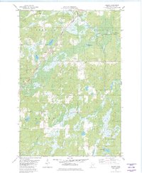
1981 Map of Kerrick
USGS Topo · Published 1982About this map
The Burlington Northern railroad corridor serves as the primary spine for this northern Pine County landscape, connecting the small settlements of Kerrick and Duquette. The terrain is defined by a dense network of wetlands and small water bodies, including L Margaret, Hicks L, and Walthausen Lake, which drain through the Willow River and its various tributaries. This 1980s-era survey reveals the geographic relationship between these remote communities and the protected expanse of the Nemadji State Forest. Cultural sites for genealogical research include St Michaels Cem, while economic activity is indicated by several Gravel Pits and a Landing Field near the river. Large-scale drainage and industrial footprints, such as the Industrial Waste Ponds to the south, contrast with the natural timberlands that dominate the township boundaries.
Find a feature on this map
23 named features on this map. Tap any name to fly to it.
Don’t see what you’re looking for? This feature index may not catch every label — zoom into the map to look around manually.
Map Details
Editions of this 1981 Kerrick Map
This is the sole edition of this map. No revisions or reprints were ever made.
Other maps of this area

1949 · Danbury
USGS Topo · 1:48,000

1949 · Holyoke
USGS Topo · 1:48,000

1953 · Duluth
USGS Topo · 1:250,000

1958 · Duluth
USGS Topo · 1:250,000

1962 · Holyoke
USGS Topo · 1:62,500

1962 · Bruno
USGS Topo · 1:62,500

1962 · Cloverdale
USGS Topo · 1:62,500

1962 · Danbury
USGS Topo · 1:62,500

1980 · Sandstone
USGS Topo · 1:100,000
1981 · Askov Lookout Tower
USGS Topo · 1:24,000