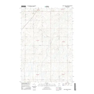
2016 Map of Askov Lookout Tower
USGS Topo · Published 2016About this map
Askov Lookout Tower serves as a prominent landmark in this Pine County landscape, situated atop the terrain north of Root Rd. The region is defined by a dense network of watercourses, including the meandering Sand Cr and the waters of Scott Dixon Pond. Settlement patterns are traced through rural roads named for early families and local geography, such as Pickeral Creek Rd and Tauer Horbacz Ln. For those researching local genealogy or township history, the Vilstad Lutheran Cem sits along One Mile Rd, marking a point of community heritage amidst the wetlands and woodlands. The map illustrates a rural environment where land management is segmented by townships T44N, T43N, and T42N, with drainage provided by several named creeks including Partridge Cr, Hay Cr, and Wolf Cr.
Find a feature on this map
42 named features on this map. Tap any name to fly to it.
Don’t see what you’re looking for? This feature index may not catch every label — zoom into the map to look around manually.
Map Details
Editions of this 2016 Askov Lookout Tower Map
This is the sole edition of this map. No revisions or reprints were ever made.
Other maps of this area

1953 · Duluth
USGS Topo · 1:250,000

1958 · Duluth
USGS Topo · 1:250,000

1961 · Sandstone
USGS Topo · 1:62,500

1961 · Moose Lake
USGS Topo · 1:62,500

1962 · Bruno
USGS Topo · 1:62,500

1962 · Cloverdale
USGS Topo · 1:62,500

1980 · Sandstone
USGS Topo · 1:100,000
1981 · Cloverdale
USGS Topo · 1:24,000
1981 · Askov Lookout Tower
USGS Topo · 1:24,000
1981 · Kerrick
USGS Topo · 1:24,000
Featured Places
- Norman Township, MN
- Danforth Township, MN
- Bruno Township, MN
- Partridge Township, MN
- Sandstone Township, MN