
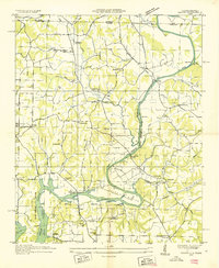
1936 Map of Aspen Hill
USGS Topo · Published 1936About this map
Giles County agriculture and rural industry center on the Louisville and Nashville Railroad corridor during this 1936 Tennessee Valley Authority and USGS collaboration. The rail line serves the established community of Aspen Hill and the Prospect Station Post Office in the south, while the surrounding landscape is defined by a high density of country schools and churches. Features like Beasley Chapel School, Willow Grove School, and New Zion Church suggest a tightly knit social fabric organized around the numerous hollows and creek branches.
Find a feature on this map
86 named features on this map. Tap any name to fly to it.
Don’t see what you’re looking for? This feature index may not catch every label — zoom into the map to look around manually.
Map Details
Editions of this 1936 Aspen Hill Map
This is the sole edition of this map. No revisions or reprints were ever made.
Other maps of this area

1888 · Huntsville
USGS Topo · 1:125,000

1892 · Huntsville
USGS Topo · 1:125,000

1936 · Union Hill
USGS Topo · 1:24,000

1936 · Elkmont
USGS Topo · 1:24,000

1936 · Pulaski
USGS Topo · 1:24,000

1936 · Bodenham
USGS Topo · 1:24,000

1936 · Appleton
USGS Topo · 1:24,000

1936 · Tarpley
USGS Topo · 1:24,000

1936 · Elkton
USGS Topo · 1:24,000
1936 · Salem
USGS Topo · 1:24,000