
1925 Map of Aspermont 4-a
USGS Topo · Published 1925About this map
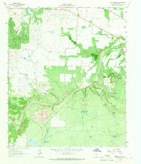
Old Glory serves as the primary hub in the southeastern corner of this mid-1920s survey, situated along the Denver railroad and State Highway No 18. The landscape is dominated by the winding path of the Salt Fork of Brazos River, where crucial river access points like Redhorse Crossing and Robinson Crossing provided transit in an era of growing infrastructure. A distinct network of rural community institutions is visible across the terrain, including Davidson School, Sandlin School, New Hope School, and Hooker School. This distribution of schools, along with the Grand View Church and a lone Cemetery, reflects a settled agricultural society where local education and faith were organized around family homesteads and the river's drainage basins. The survey captures a moment when traditional river crossings were still vital alongside the developing state highway system.
Find a feature on this map
13 named features on this map. Tap any name to fly to it.
Don’t see what you’re looking for? This feature index may not catch every label — zoom into the map to look around manually.
Map Details
Editions of this 1925 Aspermont 4-a Map
This is the sole edition of this map. No revisions or reprints were ever made.
Other maps of this area

1925 · Haskell 3-b
USGS Topo · 1:48,000

1931 · Aspermont
USGS Topo · 1:62,500

1954 · Lubbock
USGS Topo · 1:250,000

1954 · Wichita Falls
USGS Topo · 1:250,000

1958 · Wichita Falls
USGS Topo · 1:250,000

1962 · Kiowa Peak
USGS Topo · 1:24,000
1962 · Frog Mountain
USGS Topo · 1:24,000

1964 · Sagerton
USGS Topo · 1:24,000

1965 · Jud
USGS Topo · 1:24,000

1967 · Kiowa Peak SW
USGS Topo · 1:24,000