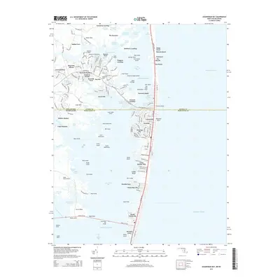
2014 Map of Assawoman Bay
USGS Topo · Published 2014About this map
Fenwick Island serves as the focal point for this coastal survey, where the Delaware-Maryland state line bisects the barrier beach. The landscape is defined by the intricate relationship between the Atlantic Ocean and the back bays, including Little Assawoman Bay and the larger Assawoman Bay. Extensive development along the shoreline is evident in residential communities like Montego Bay, Caine Harbor Mile, and Keen-Wik. On the mainland side of the Delmarva Peninsula, the geography is characterized by numerous necks and points, such as Miller Neck and Greys Neck, punctuated by historic landing sites like Sassafras Landing and Mulberry Landing. The map traces the critical corridor of Coastal Hwy as it connects these seaside settlements, while significant natural features like Isle of Wight and Reedy Island remain prominent in the shallow waters of the bay.
Find a feature on this map
182 named features on this map. Tap any name to fly to it.
Don’t see what you’re looking for? This feature index may not catch every label — zoom into the map to look around manually.
Map Details
Editions of this 2014 Assawoman Bay Map
This is the sole edition of this map. No revisions or reprints were ever made.
Other maps of this area

1901 · Ocean City
USGS Topo · 1:62,500

1918 · Rehoboth
USGS Topo · 1:62,500

1938 · Rehoboth
USGS Topo · 1:62,500

1942 · Ocean City
USGS Topo · 1:62,500

1942 · Ocean City
USGS Topo · 1:24,000

1943 · Selbyville
USGS Topo · 1:31,680
1943 · Berlin
USGS Topo · 1:31,680
1943 · Ocean City
USGS Topo · 1:31,680
1943 · Assawoman Bay
USGS Topo · 1:31,680
1943 · Bethany Beach
USGS Topo · 1:24,000