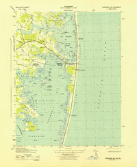
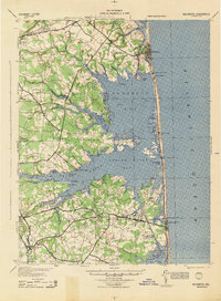
1943 Map of Assawoman Bay
USGS Topo · Published 1943About this map
Fenwick Island Lighthouse stands as a primary maritime landmark on this mid-century survey of the Maryland and Delaware coastline. The landscape is defined by the intricate waterways separating the mainland from the barrier beach, where the Atlantic Ocean meets the shore at Maryland Beach. Inland, the geography is a complex network of necks and coves, including Miller Neck and Dirickson Neck, punctuated by numerous named hammocks and islands like Corn Hammock and Horse I.
Find a feature on this map
79 named features on this map. Tap any name to fly to it.
Don’t see what you’re looking for? This feature index may not catch every label — zoom into the map to look around manually.
Map Details
Editions of this 1943 Assawoman Bay Map
This is the sole edition of this map. No revisions or reprints were ever made.
Other maps of this area

1901 · Ocean City
USGS Topo · 1:62,500

1918 · Rehoboth
USGS Topo · 1:62,500

1938 · Rehoboth
USGS Topo · 1:62,500

1942 · Ocean City
USGS Topo · 1:62,500

1942 · Ocean City
USGS Topo · 1:24,000

1943 · Selbyville
USGS Topo · 1:31,680
1943 · Berlin
USGS Topo · 1:31,680
1943 · Ocean City
USGS Topo · 1:31,680
1943 · Bethany Beach
USGS Topo · 1:24,000
1944 · Rehoboth
USGS Topo · 1:62,500