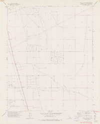
1973 Map of Astley Rancho
USGS Topo · Published 1976About this map
Astley Rancho and a network of desert thoroughfares define this high-desert landscape in San Bernardino County. The map documents an era of dispersed settlement and resource exploration, marked by numerous Drill Holes and various Prospects scattered across the arid terrain. The southern portion of the sheet shows evidence of early industrial activity at the Princess Pat Mine, which is accessed via the appropriately named Princess Pat Mine Road.
Find a feature on this map
19 named features on this map. Tap any name to fly to it.
Don’t see what you’re looking for? This feature index may not catch every label — zoom into the map to look around manually.
Map Details
Editions of this 1973 Astley Rancho Map
2 editions found
Other maps of this area

1932 · Barstow
USGS Topo · 1:125,000

1934 · Barstow
USGS Topo · 1:125,000

1937 · Shadow Mountains
USGS Topo · 1:48,000

1937 · Kramer
USGS Topo · 1:48,000

1942 · Kramer
USGS Topo · 1:62,500

1942 · Shadow Mountains
USGS Topo · 1:62,500

1947 · Kramer
USGS Topo · 1:24,000

1947 · Red Buttes
USGS Topo · 1:24,000

1953 · San Bernardino
USGS Topo · 1:250,000
1955 · Shadow Mountains
USGS Topo · 1:24,000