
1919 Map of Astoria
USGS Topo · Published 1928About this map
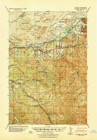
Astoria sits at the strategic confluence of the Columbia River and Youngs Bay, serving as a critical maritime and rail hub during this post-war period. The landscape is defined by its military and industrial infrastructure, from the coastal defenses at Fort Stevens to the S P & S Ry tracks that connect the shoreline settlements. South of the main port, the Lewis and Clark River and Youngs River snake through tidal flats and timbered ridges, while smaller communities like Warrenton and Hammond manage the river traffic. Along the Pacific Ocean coastline, the survey captures the long stretch of Delaura Beach and the shifting sands of Clatsop Spit, providing a clear record of the region's topography before mid-century development altered the estuary's natural and man-made features.
Find a feature on this map
47 named features on this map. Tap any name to fly to it.
Don’t see what you’re looking for? This feature index may not catch every label — zoom into the map to look around manually.
Map Details
Editions of this 1919 Astoria Map
This is the sole edition of this map. No revisions or reprints were ever made.
Other maps of this area

1938 · Cape Disappointment
USGS Topo · 1:62,500

1938 · Fort Columbia
USGS Topo · 1:62,500

1939 · Astoria
USGS Topo · 1:62,500

1939 · Saddle Mountain
USGS Topo · 1:62,500
1940 · Svensen
USGS Topo · 1:62,500

1940 · Brookfield
USGS Topo · 1:62,500

1940 · Cape Falcon
USGS Topo · 1:62,500

1943 · Fort Columbia
USGS Topo · 1:62,500

1943 · Saddle Mtn.
USGS Topo · 1:62,500

1943 · Copalis Beach
USGS Topo · 1:250,000