1990 Map of Atchison
USGS Topo · Published 1990About this map
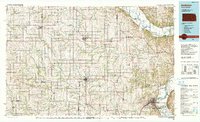
The Missouri River carves a sharp border between Kansas and Missouri, anchoring a landscape defined by significant historic transit corridors and educational institutions. This 1990 revision, based on surveys dating back to 1959, captures the Kickapoo Indian Reservation and a network of agricultural settlements like Sabetha, Hiawatha, and Atchison. The presence of St Benedicts College and Highland Junior College suggests the area's long-standing role as a regional center for higher education.
Find a feature on this map
158 named features on this map. Tap any name to fly to it.
Don’t see what you’re looking for? This feature index may not catch every label — zoom into the map to look around manually.
Map Details
Editions of this 1990 Atchison Map
This is the sole edition of this map. No revisions or reprints were ever made.
Other maps of this area

1885 · Atchison
USGS Topo · 1:125,000

1886 · Oskaloosa
USGS Topo · 1:125,000

1888 · Oskaloosa
USGS Topo · 1:125,000

1888 · Atchison
USGS Topo · 1:125,000

1888 · Hiawatha
USGS Topo · 1:125,000

1889 · Seneca
USGS Topo · 1:125,000

1889 · Wamego
USGS Topo · 1:125,000

1889 · Topeka
USGS Topo · 1:125,000

1890 · Kansas City
USGS Topo · 1:125,000

1893 · Atchison
USGS Topo · 1:125,000