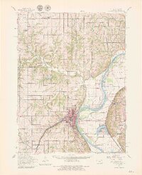
1960 Map of Atchison
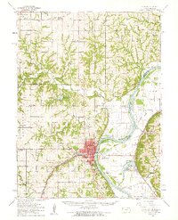
USGS Topo · Published 1979About this map
The Missouri River forms a sweeping boundary through this region, carving deep oxbows like McQueen Bend and Rushville Bend that define the border between Kansas and Missouri. The city of Atchison serves as the focal point, where the Chicago Rock Island And Pacific and other rail lines converge to cross the water. The floodplain is dotted with numerous bodies of water including Horseshoe Lake, Mud Lake, and Lewis and Clark Lake, illustrating the river's historical migration across the valley floor.
Find a feature on this map
77 named features on this map. Tap any name to fly to it.
Don’t see what you’re looking for? This feature index may not catch every label — zoom into the map to look around manually.
Map Details
Editions of this 1960 Atchison Map
2 editions found
Other maps of this area

1885 · Atchison
USGS Topo · 1:125,000

1886 · Oskaloosa
USGS Topo · 1:125,000

1888 · Oskaloosa
USGS Topo · 1:125,000

1888 · Atchison
USGS Topo · 1:125,000

1890 · Kansas City
USGS Topo · 1:125,000

1893 · Atchison
USGS Topo · 1:125,000

1894 · Kansas City
USGS Topo · 1:125,000

1894 · Oskaloosa
USGS Topo · 1:125,000

1910 · Leavenworth
USGS Topo · 1:62,500

1924 · St. Joseph
USGS Topo · 1:62,500