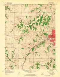
1959 Map of Atchison West
USGS Topo · Published 1960About this map
The railroad corridors of the Missouri Pacific and the Atchison Topeka and Santa Fe define the economic landscape of this eastern Kansas region in the late 1950s. While the urban core of Atchison begins to expand westward with landmarks like the Amelia Earhart Stadium and Franklin Sch, the surrounding landscape remains deeply rooted in its agrarian township structure. This rural character is reflected in the dense network of country schools, including Good Intent Sch, Deer Creek Sch, and Float Sch, which served the farming families of Shannon and Mount Pleasant townships.
Find a feature on this map
42 named features on this map. Tap any name to fly to it.
Don’t see what you’re looking for? This feature index may not catch every label — zoom into the map to look around manually.
Map Details
Editions of this 1959 Atchison West Map
2 editions found
Other maps of this area

1885 · Atchison
USGS Topo · 1:125,000

1886 · Oskaloosa
USGS Topo · 1:125,000

1888 · Oskaloosa
USGS Topo · 1:125,000

1888 · Atchison
USGS Topo · 1:125,000

1893 · Atchison
USGS Topo · 1:125,000

1894 · Oskaloosa
USGS Topo · 1:125,000

1926 · Atchison
USGS Topo · 1:62,500

1948 · Oak Mills
USGS Topo · 1:24,000

1950 · Kansas City
USGS Topo · 1:250,000
1951 · Oak Mills
USGS Topo · 1:24,000