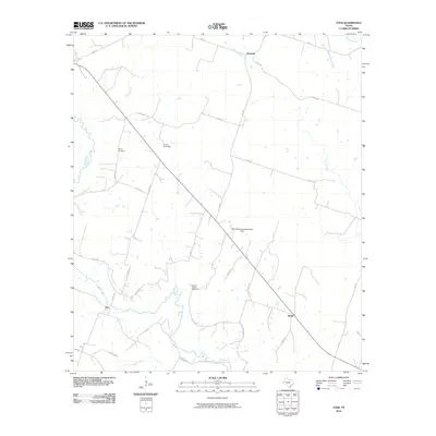
2010 Map of Ater
USGS Topo · Published 2010About this map
The Leon River and its numerous tributaries, including Kelly Branch and Plum Creek, dominate the rural topography of this Coryell County landscape. Several small historic communities are dispersed along the road network, including the eponymous Ater, as well as Pancake to the north and Ames to the southeast. For genealogists, the map provides precise locations for several family and community burial grounds, such as Wood Cemetery, Young Cemetery, and Weaver Chapel Cemetery, which are often the primary remaining evidence of early settlement patterns in this part of Texas. Modern land management is represented by the M D M Grazing Association Dam, while the transition toward the drainage basins of the Middle Bosque River and Coryell Creek suggests a highly dissected terrain defined by its watercourses and farm-to-market roads like FM 217.
Find a feature on this map
33 named features on this map. Tap any name to fly to it.
Don’t see what you’re looking for? This feature index may not catch every label — zoom into the map to look around manually.
Map Details
Editions of this 2010 Ater Map
This is the sole edition of this map. No revisions or reprints were ever made.
Other maps of this area

1888 · Meridian
USGS Topo · 1:125,000

1894 · Meridian
USGS Topo · 1:125,000

1894 · Gatesville
USGS Topo · 1:125,000

1947 · Purmela
USGS Topo · 1:62,500

1947 · Gatesville West
USGS Topo · 1:24,000

1947 · Purmela
USGS Topo · 1:24,000

1947 · Gatesville East
USGS Topo · 1:24,000
1950 · Gatesville
USGS Topo · 1:62,500

1954 · Waco
USGS Topo · 1:250,000
1954 · Gatesville West
USGS Topo · 1:24,000