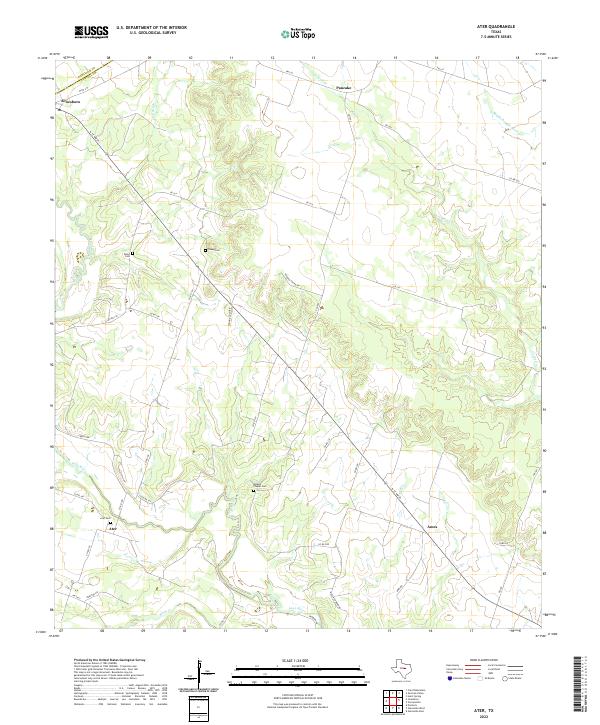
2022 Map of Ater
USGS Topo · Published 2022About this map
The Leon River snakes across the southwestern corner of this landscape, carving a distinct valley through the rural terrain of Coryell County and Hamilton County. Small, enduring communities such as Jonesboro and Pancake anchor the northern reaches, while the hamlets of Ater and Ames sit further south along the winding course of the river and Coryell Creek. This area is defined by its deep-rooted family heritage, evidenced by the numerous small burial grounds dispersed throughout the countryside, including Weaver Chapel Cemetery, Young Cemetery, and Wood Cemetery. The drainage network, featuring Kelly Branch and the Middle Bosque River, dictates the placement of the regional road system, where corridors like North State Highway 36 and FM 217 connect these isolated settlements. The map illustrates a classic Central Texas agricultural pattern of creek-side farming and upland ranching that has persisted for generations.
Find a feature on this map
43 named features on this map. Tap any name to fly to it.
Don’t see what you’re looking for? This feature index may not catch every label — zoom into the map to look around manually.
Map Details
Editions of this 2022 Ater Map
This is the sole edition of this map. No revisions or reprints were ever made.
Other maps of this area

1888 · Meridian
USGS Topo · 1:125,000

1894 · Meridian
USGS Topo · 1:125,000

1894 · Gatesville
USGS Topo · 1:125,000

1947 · Purmela
USGS Topo · 1:62,500

1947 · Gatesville West
USGS Topo · 1:24,000

1947 · Purmela
USGS Topo · 1:24,000

1947 · Gatesville East
USGS Topo · 1:24,000
1950 · Gatesville
USGS Topo · 1:62,500

1954 · Waco
USGS Topo · 1:250,000
1954 · Gatesville West
USGS Topo · 1:24,000