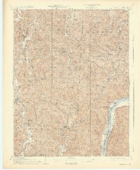
1908 Map of Athalia
USGS Topo · Published 1926About this map
Ohio River commerce and agricultural hill country define this survey of Lawrence and Gallia counties. Before the widespread adoption of highway bridges, the Crown City Ferry and Millersport Ferry served as vital links across the water to West Virginia, connecting riverside towns like Crown City and Athalia to the Baltimore and Ohio RR corridor. The interior is characterized by a dense network of hollows and ridges, such as Greasy Ridge, where small communities like Arabia, Wilgus, and Scottown established themselves along creek beds. Genealogists will find a wealth of localized data, including the Aid PO, several country houses of worship like Dickey Church and Mt Moriah Church, and numerous rural schoolhouses such as Low Gap School and Campbell School that anchored these early 20th-century neighborhoods.
Find a feature on this map
76 named features on this map. Tap any name to fly to it.
Don’t see what you’re looking for? This feature index may not catch every label — zoom into the map to look around manually.
Map Details
Editions of this 1908 Athalia Map
3 editions found

Other maps of this area

1892 · Huntington
USGS Topo · 1:125,000

1898 · Huntington
USGS Topo · 1:125,000

1898 · Ironton
USGS Topo · 1:62,500

1900 · Ironton
USGS Topo · 1:62,500

1901 · Guyandot
USGS Topo · 1:62,500

1901 · Ceredo
USGS Topo · 1:62,500

1902 · Guyandot
USGS Topo · 1:62,500

1902 · Milton
USGS Topo · 1:62,500

1903 · Kenova
USGS Topo · 1:125,000

1904 · Kenova
USGS Topo · 1:125,000