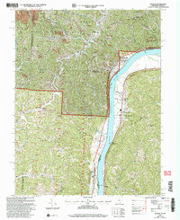
2002 Map of Athalia
USGS Topo · Published 2006About this map
The Ohio River carves a deep valley between Lawrence County, Ohio, and Cabell County, West Virginia, serving as the central artery for several riverside communities. Along the western shore, the village of Athalia and the town of Crown City sit beneath the steep hillsides of the Wayne National Forest. These settlements are connected by a Scenic Byway that traces the riverbank, passing rural landmarks like Dillon Chapel and Millersport. Across the water in West Virginia, Green Bottom and Lesage occupy the narrow floodplains beneath the rising bluffs.
Find a feature on this map
37 named features on this map. Tap any name to fly to it.
Don’t see what you’re looking for? This feature index may not catch every label — zoom into the map to look around manually.
Map Details
Editions of this 2002 Athalia Map
This is the sole edition of this map. No revisions or reprints were ever made.
Other maps of this area

1892 · Huntington
USGS Topo · 1:125,000

1898 · Huntington
USGS Topo · 1:125,000

1901 · Guyandot
USGS Topo · 1:62,500

1902 · Guyandot
USGS Topo · 1:62,500

1902 · Milton
USGS Topo · 1:62,500

1906 · Athalia
USGS Topo · 1:62,500

1906 · Glenwood
USGS Topo · 1:62,500

1908 · Athalia
USGS Topo · 1:62,500

1908 · Glenwood
USGS Topo · 1:62,500

1931 · Milton
USGS Topo · 1:62,500