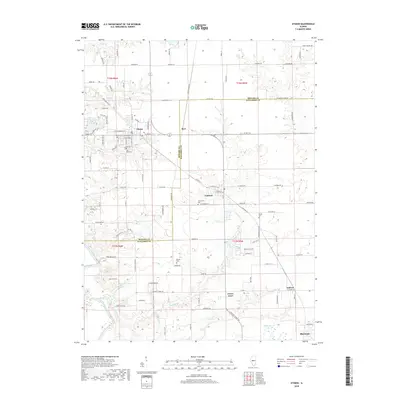
2018 Map of Athens
USGS Topo · Published 2018About this map
Athens and Cantrall anchor this portrait of the central Illinois plains, situated along the border of Menard and Sangamon counties. The landscape is defined by the winding course of the Sangamon River in the southwest and the many small drainages like Halls Br and Cantrall Cr that carve through the agricultural tablelands. For family historians, the map is remarkably dense with burial sites, including the centrally located Joel Hall Cem and the West Cem near the town center. The settlement pattern follows a grid of rural roads such as Shanghi Ln and Haggard Rd, punctuated by smaller communities like Barr, Andrew, and the northern edge of Sherman. This era of the landscape shows a mix of traditional farmstead layouts and newer water features like Country Lake, Cica Lake, and Halfmoon Lake, illustrating the transition from a purely agrarian economy to one with growing residential and recreational pockets.
Find a feature on this map
104 named features on this map. Tap any name to fly to it.
Don’t see what you’re looking for? This feature index may not catch every label — zoom into the map to look around manually.
Map Details
Editions of this 2018 Athens Map
This is the sole edition of this map. No revisions or reprints were ever made.
Other maps of this area

1907 · Springfield
USGS Topo · 1:62,500

1909 · Tallula
USGS Topo · 1:62,500

1930 · Springfield
USGS Topo · 1:62,500

1933 · Petersburg
USGS Topo · 1:62,500

1938 · Petersburg
USGS Topo · 1:62,500

1940 · Tallula
USGS Topo · 1:62,500

1940 · Springfield
USGS Topo · 1:62,500

1948 · Mason City
USGS Topo · 1:62,500

1949 · Mason City
USGS Topo · 1:62,500

1950 · Springfield West
USGS Topo · 1:24,000