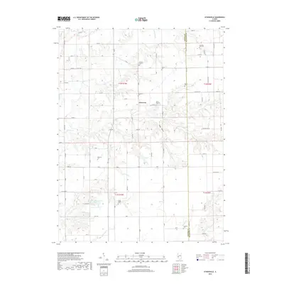
2018 Map of Athensville
USGS Topo · Published 2018About this map
Athensville sits at the heart of this agricultural landscape in Greene County, where the township lines of t12n r10w and t12n r9w meet. The terrain is deeply carved by drainage systems like Apple Cr, Negro Lick, and Bear Cr, creating a complex network of ridges and hollows such as Happy Hollow. This 2018 survey reveals a high density of rural burial sites, including the Athensville Cem, Reeve-Mayberry Cem, and Sheppard Cem, which serve as vital markers for local genealogists. In the southern portion of the quadrangle, Woodbine Country Club Lake provides a rare structured water feature amidst the natural flow of Cole Br and Little Bear Cr. The map captures the enduring rural character of the region, where the boundary between Greene Co and Macoupin Co is defined by a grid of county roads and the natural path of Rubicon Cr.
Find a feature on this map
80 named features on this map. Tap any name to fly to it.
Don’t see what you’re looking for? This feature index may not catch every label — zoom into the map to look around manually.
Map Details
Editions of this 2018 Athensville Map
This is the sole edition of this map. No revisions or reprints were ever made.
Other maps of this area

1924 · Winchester
USGS Topo · 1:48,000

1924 · Roodhouse
USGS Topo · 1:62,500

1926 · Winchester
USGS Topo · 1:62,500

1926 · Roodhouse
USGS Topo · 1:62,500

1932 · Greenfield
USGS Topo · 1:62,500

1932 · Jacksonville
USGS Topo · 1:62,500

1937 · Jacksonville
USGS Topo · 1:62,500

1948 · Quincy
USGS Topo · 1:250,000

1956 · Quincy
USGS Topo · 1:250,000
1983 · Manchester
USGS Topo · 1:24,000