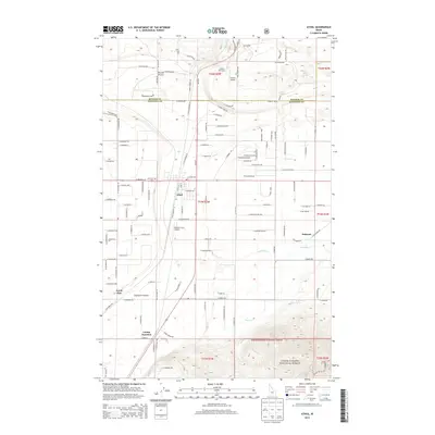
2013 Map of Athol
USGS Topo · Published 2013About this map
Athol occupies the center of this landscape, situated within the distinct geological formation known as the Purcell Trench. This 2013 survey reveals a transitional area where the residential streets of Athol and the smaller community of Belmont meet the timbered slopes of the Coeur d'Alene National Forest. Aviation is a prominent theme in the local infrastructure, with Western Spur Airport, Hackney Airpark, and Granite Airport all situated within a few miles of each other, reflecting the importance of light aircraft in this part of northern Idaho. To the south, Eightmile Prairie provides a level break in the terrain near Corbin Junction and the small settlement of North Pole. Notable local landmarks for researchers include the Mtn View Cem and the waters of Lewellen Cr and Sage Cr, which drain the eastern portions of the quadrangle.
Find a feature on this map
109 named features on this map. Tap any name to fly to it.
Don’t see what you’re looking for? This feature index may not catch every label — zoom into the map to look around manually.
Map Details
Editions of this 2013 Athol Map
This is the sole edition of this map. No revisions or reprints were ever made.
Other maps of this area

1901 · Sandpoint
USGS Topo · 1:125,000

1903 · Rathdrum
USGS Topo · 1:125,000

1911 · Priest Lake
USGS Topo · 1:250,000

1911 · Sandpoint
USGS Topo · 1:125,000

1913 · Priest Lake
USGS Topo · 1:250,000

1955 · Spokane
USGS Topo · 1:250,000

1958 · Spokane
USGS Topo · 1:250,000

1958 · Sandpoint
USGS Topo · 1:250,000

1961 · Hayden
USGS Topo · 1:24,000

1961 · Bayview
USGS Topo · 1:24,000