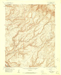
1960 Map of Atkinson Creek
USGS Topo · Published 1961About this map
Uncompahgre National Forest land dominates this western Colorado landscape, where the plateau terrain of Spring Creek Mesa is deeply incised by a complex drainage system. The map reveals a land structured by water and elevation, from the heights of Wild Cow Mesa and Long Mesa down to the carved canyons of Big Atkinson Creek and Burro Creek. Evidence of high-country land use is centered around the Spring Creek Ranch and a remote Airstrip, indicating the specialized infrastructure required for ranching and resource management in this isolated part of Mesa and Montrose Counties. Distinctive geological features like the Atkinson Breaks, Gypsum Bluff, and the natural depressions of Blue Basin and Hog Park highlight the dramatic erosional patterns typical of the region during the mid-twentieth century.
Find a feature on this map
28 named features on this map. Tap any name to fly to it.
Don’t see what you’re looking for? This feature index may not catch every label — zoom into the map to look around manually.
Map Details
Editions of this 1960 Atkinson Creek Map
3 editions found
Other maps of this area

1916 · Paradox Valley
USGS Topo · 1:125,000

1922 · Paradox Valley
USGS Topo · 1:125,000

1948 · Uravan
USGS Topo · 1:24,000

1949 · Davis Mesa
USGS Topo · 1:24,000

1949 · Uravan
USGS Topo · 1:24,000

1949 · Atkinson Creek
USGS Topo · 1:24,000

1949 · Red Canyon
USGS Topo · 1:24,000

1949 · Calamity Mesa
USGS Topo · 1:24,000

1950 · Calamity Mesa
USGS Topo · 1:24,000

1950 · Atkinson Creek
USGS Topo · 1:24,000