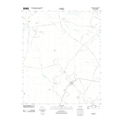
2010 Map of Atkinson
USGS Topo · Published 2010About this map
Atkinson serves as the central hub of this Pender County landscape, where the Atkinson Post Office anchors a small grid of streets surrounded by rural acreage. The terrain is defined by a complex network of wetlands and small water bodies, including Lake Ann, Cypress Lake, and the winding course of the Black River along the western edge. A distinctive geological feature, Colvins Bay, sits at the center of the sheet, illustrating the unique Carolina Bay formations prevalent in this coastal plain region.
Find a feature on this map
53 named features on this map. Tap any name to fly to it.
Don’t see what you’re looking for? This feature index may not catch every label — zoom into the map to look around manually.
Map Details
Editions of this 2010 Atkinson Map
This is the sole edition of this map. No revisions or reprints were ever made.
Other maps of this area

1953 · Florence
USGS Topo · 1:250,000

1954 · Florence
USGS Topo · 1:250,000

1954 · White Lake
USGS Topo · 1:62,500

1954 · Acme
USGS Topo · 1:62,500

1954 · Bolton
USGS Topo · 1:62,500

1955 · Atkinson
USGS Topo · 1:62,500
1980 · Point Caswell
USGS Topo · 1:24,000
1980 · Currie
USGS Topo · 1:24,000

1982 · Elizabethtown
USGS Topo · 1:100,000
1983 · Point Caswell
USGS Topo · 1:24,000