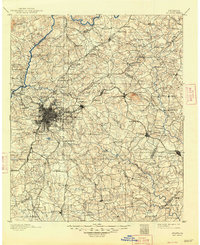
1953 Map of Atlanta
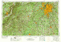
USGS Topo · Published 1973About this map
The Chattahoochee River corridor serves as the primary axis for development on this regional survey, which illustrates the mid-century expansion of Atlanta and its surrounding suburbs like Marietta and Decatur. To the west, the rugged Talladega Mountains and the Talladega National Forest dominate the Alabama side of the state line, providing a stark contrast to the burgeoning metropolitan infrastructure. Significant military installations including Fort McClellan, Dobbins AFB, and Fort McPherson underscore the region's strategic importance during the Cold War era.
Find a feature on this map
122 named features on this map. Tap any name to fly to it.
Don’t see what you’re looking for? This feature index may not catch every label — zoom into the map to look around manually.
Map Details
Editions of this 1953 Atlanta Map
2 editions found

Historical Maps of Atlanta Through Time
8 maps found