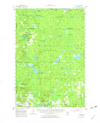
1955 Map of Atlanta
USGS Topo · Published 1982About this map
Atlanta serves as the focal point of this mid-century landscape, positioned at the junction of the Haymeadow Creek and the Thunder Bay River. The area is defined by its extensive water systems and managed timberlands within the Mackinaw State Forest. To the north, the terrain is densely dotted with glacial lakes such as Shoepac Lake and the Twin Tomahawk Lakes, while the Rainy River Dam regulates the northern flow. Evidence of earlier industrial footprints is visible in the Old Railroad Grade and numerous Gravel Pits scattered across the township lines.
Find a feature on this map
72 named features on this map. Tap any name to fly to it.
Don’t see what you’re looking for? This feature index may not catch every label — zoom into the map to look around manually.
Map Details
Editions of this 1955 Atlanta Map
3 editions found
Other maps of this area

1949 · Lewiston
USGS Topo · 1:62,500

1950 · Lewiston
USGS Topo · 1:24,000

1951 · Lewiston
USGS Topo · 1:24,000

1954 · Hetherton
USGS Topo · 1:62,500

1954 · Traverse City
USGS Topo · 1:250,000

1954 · Tawas City
USGS Topo · 1:250,000

1954 · Alpena
USGS Topo · 1:250,000

1955 · Atlanta
USGS Topo · 1:62,500

1955 · Comins
USGS Topo · 1:62,500

1955 · Hillman
USGS Topo · 1:62,500