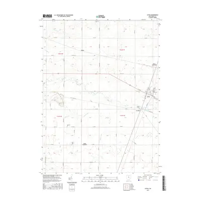
2016 Map of Attica
USGS Topo · Published 2016About this map
Attica and the surrounding township lands of Scipio are defined by a complex network of agricultural drainage and small rural settlements. The map illustrates a landscape shaped by water management, featuring numerous engineered waterways such as Porter Ditch, Kagy Ditch, and Bollinger Ditch that feed into Honey Creek. This 21st-century survey highlights the persistence of small crossroad communities like Saint Stephens and Caroline, while also documenting the infrastructure required for local utility, notably the Attica Upground Reservoir.
Find a feature on this map
72 named features on this map. Tap any name to fly to it.
Don’t see what you’re looking for? This feature index may not catch every label — zoom into the map to look around manually.
Map Details
Editions of this 2016 Attica Map
This is the sole edition of this map. No revisions or reprints were ever made.
Other maps of this area

1906 · Sycamore
USGS Topo · 1:62,500

1906 · Tiffin
USGS Topo · 1:62,500

1915 · Siam
USGS Topo · 1:62,500

1915 · Bucyrus
USGS Topo · 1:62,500

1943 · Bucyrus
USGS Topo · 1:62,500

1950 · Marion
USGS Topo · 1:250,000

1956 · Toledo
USGS Topo · 1:250,000
1960 · Watson
USGS Topo · 1:24,000
1960 · Bloomville
USGS Topo · 1:24,000
1960 · Lykens
USGS Topo · 1:24,000