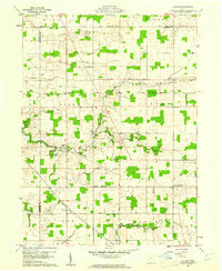
1960 Map of Lykens
USGS Topo · Published 1961About this map
Benton and Plankton anchor this mid-century portrait of rural Crawford County, where the landscape is defined by the rigid grid of section lines and the fluid meanders of Broken Sword Creek. A significant historical boundary, the Old Indian Treaty Boundary, cuts diagonally across the southern third of the map, marking a legacy of early westward expansion. The area is a mosaic of small woodlots and farmsteads, served by a network of country churches like Olive Branch Ch and Pleasant Home Ch. Transport is dominated by the New York Central railroad, which passes through Lemert in the southwest. Numerous small family or community burial grounds, including Pipetown Cem and Brundedge Cem, are scattered across the townships of Eden, Texas, and Lykens, providing valuable markers for local genealogical research.
Find a feature on this map
41 named features on this map. Tap any name to fly to it.
Don’t see what you’re looking for? This feature index may not catch every label — zoom into the map to look around manually.
Map Details
Editions of this 1960 Lykens Map
2 editions found
Other maps of this area

1906 · Sycamore
USGS Topo · 1:62,500

1906 · Tiffin
USGS Topo · 1:62,500

1915 · Siam
USGS Topo · 1:62,500

1915 · Bucyrus
USGS Topo · 1:62,500

1943 · Bucyrus
USGS Topo · 1:62,500

1950 · Marion
USGS Topo · 1:250,000

1956 · Toledo
USGS Topo · 1:250,000

1960 · Sycamore
USGS Topo · 1:24,000

1960 · Tiffin South
USGS Topo · 1:24,000

1960 · Oceola
USGS Topo · 1:24,000