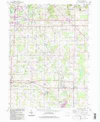
1994 Map of Atwater
USGS Topo · Published 1997About this map
Atwater and Rootstown anchor this survey of Portage County, where the rural landscape of the late twentieth century is defined by its agricultural foundations and the legacy of the Conrail line. The map captures small rural centers like New Milford (Rootstown Sta) and Edinburg, providing a detailed look at the local geography before suburban shifts significantly altered these township patterns. The southern portion of the quadrangle is dominated by the waters of Berlin Reservoir and Schultz Lake, while the north features a section of West Branch State Park. Genealogists will find considerable value in the numerous burial grounds documented, including Edinburg Cem, Homeland Cem, and Atwater Cem. The presence of several oil wells near Edinburg and a Microwave Tower in Rootstown illustrates the varied industrial and utility infrastructure that shared the landscape with long-standing family farms and small crossroad settlements.
Find a feature on this map
42 named features on this map. Tap any name to fly to it.
Don’t see what you’re looking for? This feature index may not catch every label — zoom into the map to look around manually.
Map Details
Editions of this 1994 Atwater Map
This is the sole edition of this map. No revisions or reprints were ever made.
Other maps of this area

1901 · Canton
USGS Topo · 1:62,500

1903 · Canton
USGS Topo · 1:62,500

1906 · Kent
USGS Topo · 1:62,500

1906 · Ravenna
USGS Topo · 1:62,500

1908 · Ravenna
USGS Topo · 1:62,500

1909 · Alliance
USGS Topo · 1:62,500

1950 · Cleveland
USGS Topo · 1:250,000

1951 · Canton
USGS Topo · 1:250,000

1952 · Alliance
USGS Topo · 1:24,000

1953 · Canton
USGS Topo · 1:250,000