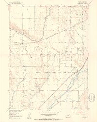
1951 Map of Atwood
USGS Topo · Published 1953About this map
The South Platte River corridor defines the landscape of Logan County in the early 1950s, serving as the central axis for both agriculture and transportation. The small settlement of Atwood is positioned at the intersection of critical infrastructure, where the Union Pacific and Chicago Burlington and Quincy railroads parallel the river's path. This era of development is marked by an extensive irrigation network, including the North Pawnee Ditch, Springdale Ditch, and Schneider Ditch, which redirect water from the river and Pawnee Creek to support the surrounding plains.
Find a feature on this map
16 named features on this map. Tap any name to fly to it.
Don’t see what you’re looking for? This feature index may not catch every label — zoom into the map to look around manually.
Map Details
Editions of this 1951 Atwood Map
4 editions found
Other maps of this area

1951 · Willard
USGS Topo · 1:24,000

1951 · Messex
USGS Topo · 1:24,000

1951 · Sterling South
USGS Topo · 1:24,000

1951 · Sterling North
USGS Topo · 1:24,000

1951 · Wild Horse Lake
USGS Topo · 1:24,000

1951 · Atwood NE
USGS Topo · 1:24,000

1951 · Merino
USGS Topo · 1:24,000

1951 · Atwood
USGS Topo · 1:24,000

1954 · Sterling
USGS Topo · 1:250,000

1958 · Sterling
USGS Topo · 1:250,000