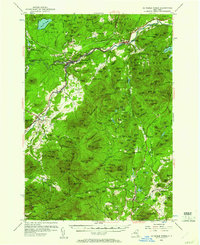
1953 Map of Au Sable Forks
USGS Topo · Published 1961About this map
The Ausable River and its West Branch converge at Au Sable Forks, a central point for this 1950s Adirondack landscape. The Delaware and Hudson railroad tracks parallel the river's path, serving industrial sites like the Ore Mines near Thomasville and the Strip Mine further south. This map documents a period of active resource extraction and localized settlement, where small hamlets like Clintonville and Black Brook are clearly defined alongside rural infrastructure including the Arnold Hill Sch and various brick-and-mortar operations like Soper Kiln.
Find a feature on this map
184 named features on this map. Tap any name to fly to it.
Don’t see what you’re looking for? This feature index may not catch every label — zoom into the map to look around manually.
Map Details
Editions of this 1953 Au Sable Forks Map
3 editions found
Other maps of this area

1894 · Elizabethtown
USGS Topo · 1:62,500

1894 · Port Henry
USGS Topo · 1:62,500

1894 · Plattsburg
USGS Topo · 1:62,500

1895 · Willsboro
USGS Topo · 1:62,500

1895 · Elizabethtown
USGS Topo · 1:62,500

1895 · Mt. Marcy
USGS Topo · 1:62,500

1895 · Ausable
USGS Topo · 1:62,500

1896 · Lake Placid
USGS Topo · 1:62,500

1898 · Port Henry
USGS Topo · 1:62,500

1898 · Lake Placid
USGS Topo · 1:62,500