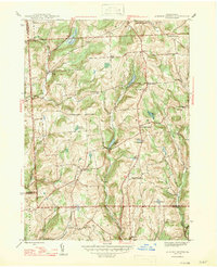
1947 Map of Auburn Center
USGS Topo · Published 1947About this map
The rolling highlands of southern Susquehanna County are defined by a network of small upland ponds and the headwaters of numerous creeks in the years following World War II. At the heart of the landscape sits Auburn Center, surrounded by numerous family-named crossroads like Harris Corners, Chase Corners, and Green Corners. This agricultural and rural territory is anchored by community landmarks such as St Bonaventure Ch and Jersey Hill Ch, while the Boles Cem. provides a genealogical touchstone for local families. The terrain is notably water-rich, featuring White Pond, Lott Pond, and the Robert Swamp. A modern technological imprint is visible on the landscape near the southern border in the form of an Airway Beacon, positioned atop the ridges to guide mid-century aviation through the Appalachian plateau.
Find a feature on this map
40 named features on this map. Tap any name to fly to it.
Don’t see what you’re looking for? This feature index may not catch every label — zoom into the map to look around manually.
Map Details
Editions of this 1947 Auburn Center Map
2 editions found
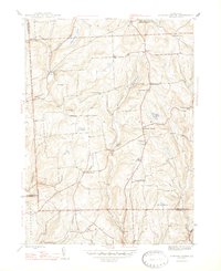
Other maps of this area

1943 · Montrose
USGS Topo · 1:62,500

1943 · Le Raysville
USGS Topo · 1:62,500

1945 · Montrose
USGS Topo · 1:62,500

1945 · Le Raysville
USGS Topo · 1:62,500

1945 · Meshoppen
USGS Topo · 1:62,500

1945 · Auburn Center
USGS Topo · 1:24,000

1945 · Jenningsville
USGS Topo · 1:24,000

1945 · Meshoppen
USGS Topo · 1:24,000

1945 · Laceyville
USGS Topo · 1:24,000

1946 · Tunkhannock
USGS Topo · 1:62,500
Featured Places
- Rush Township, PA
- Scranton Corners, Meshoppen Township
- Auburn Center, PA
- Stevens Township, PA
- Tuscarora Township, PA