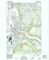
1949 Map of Auburn
USGS Topo · Published 1995About this map
The Green River valley and its surrounding plateaus define this detailed mid-century survey, revealing a landscape transitioning from agrarian foundations to suburban and industrial development. In Auburn, the dense cluster of municipal buildings and transit hubs like the Auburn Municipal Airport and the Interurban rail corridor contrast with the open spaces of the Muckleshoot Indian Reservation and the broad Muckleshoot Prairie. The map captures several small communities such as Stuck, Algona, and Meredith, many of which developed around the region's early transportation networks.
Find a feature on this map
85 named features on this map. Tap any name to fly to it.
Don’t see what you’re looking for? This feature index may not catch every label — zoom into the map to look around manually.
Map Details
Editions of this 1949 Auburn Map
5 editions found

Other maps of this area

1897 · Tacoma
USGS Topo · 1:125,000

1900 · Tacoma
USGS Topo · 1:125,000

1941 · Tacoma South
USGS Topo · 1:62,500

1942 · Lake Tapps
USGS Topo · 1:62,500

1944 · Lake Tapps
USGS Topo · 1:62,500

1944 · Tacoma South
USGS Topo · 1:62,500

1949 · Maple Valley
USGS Topo · 1:24,000

1949 · Black Diamond
USGS Topo · 1:24,000

1949 · Poverty Bay
USGS Topo · 1:24,000

1949 · Renton
USGS Topo · 1:24,000