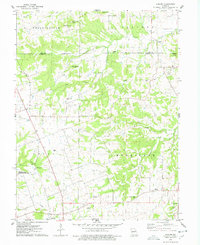
1975 Map of Auburn
USGS Topo · Published 1978About this map
Auburn serves as the primary settlement on this mid-1970s survey of the borderlands between Lincoln and Pike counties. The landscape is defined by the headwaters of numerous creeks, including North Fork, South Fork, and Mill Creek, which carve through prominent elevations like Springston Knob and Tedlock Knob. Evidence of former transportation networks is visible in the Old RR Grade running through the western sections of the map, while the Pipeline indicates more modern utility development near the town. For genealogists and local historians, the sheet is exceptionally dense with family-named landmarks and cemeteries, such as the Mitchell-Reynolds Cem, Howdeshell Cem, and Halley-Liles Cem. The southwestern portion is dominated by the William Logan State Wildlife Area, reflecting the area's transition toward protected natural spaces.
Find a feature on this map
40 named features on this map. Tap any name to fly to it.
Don’t see what you’re looking for? This feature index may not catch every label — zoom into the map to look around manually.
Map Details
Editions of this 1975 Auburn Map
2 editions found
Other maps of this area

1890 · Louisiana
USGS Topo · 1:125,000

1930 · Nebo
USGS Topo · 1:62,500

1934 · Nebo
USGS Topo · 1:48,000

1934 · Elsberry
USGS Topo · 1:48,000

1937 · Silex
USGS Topo · 1:62,500

1937 · Bowling Green
USGS Topo · 1:62,500

1939 · Silex
USGS Topo · 1:48,000

1940 · Bowling Green
USGS Topo · 1:62,500

1942 · Nebo
USGS Topo · 1:62,500

1942 · Elsberry
USGS Topo · 1:62,500