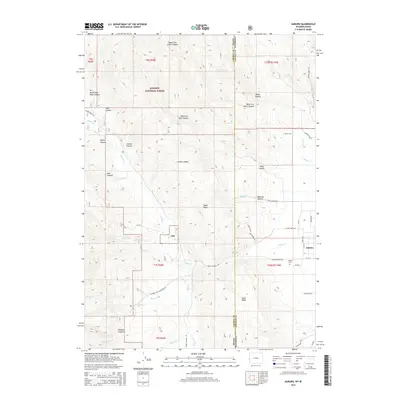
2015 Map of Auburn
USGS Topo · Published 2015About this map
The settlement of Auburn sits at the edge of the Salt River Valley, where the high-altitude terrain of the Caribou Range begins its ascent westward into the Caribou National Forest. This 2015 study details a landscape defined by significant elevation changes and seasonal watercourses, including Stump Cr and Tygee Cr. A notable local landmark is the Wyoming Fish Hatchery Ext, which points to the region's managed aquatic resources near Spring Cr. The map reveals the intricate network of canyons—such as Webster Canyon and Marthas Canyon—that carve through the limestone and shale ridges of the Idaho and Wyoming border. For genealogists, the Auburn Cem provides a specific point of reference for early families in this corner of Lincoln County, while several trails and named roads like Smoky Canyon Rd trace the path of historic transit through the mountains.
Find a feature on this map
46 named features on this map. Tap any name to fly to it.
Don’t see what you’re looking for? This feature index may not catch every label — zoom into the map to look around manually.
Map Details
Editions of this 2015 Auburn Map
This is the sole edition of this map. No revisions or reprints were ever made.
Other maps of this area

1915 · Freedom
USGS Topo · 1:62,500

1915 · Crow Creek
USGS Topo · 1:62,500

1921 · Afton
USGS Topo · 1:125,000

1949 · Stewart Flat
USGS Topo · 1:24,000

1951 · Stewart Flat
USGS Topo · 1:24,000

1955 · Preston
USGS Topo · 1:250,000

1958 · Preston
USGS Topo · 1:250,000

1962 · Preston
USGS Topo · 1:250,000
1980 · Grover
USGS Topo · 1:24,000
1980 · Thayne West
USGS Topo · 1:24,000