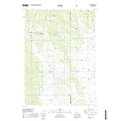
2018 Map of Auburn
USGS Topo · Published 2018About this map
Auburn anchors the eastern edge of this 2018 survey, situated in the fertile Star Valley along the Idaho-Wyoming border. The landscape is defined by the sharp transition between the valley floor and the high elevations of the Caribou Range to the west, where the Caribou National Forest protects a complex network of canyons and ridges. Waterways like Stump Cr and Webster Cr emerge from deep drainages such as Webster Canyon and Graehl Canyon to feed the valley's agricultural lands. The map reveals a rural infrastructure of local connectors like Fish Hatchery Rd and Farmers Field Rd, alongside markers of local heritage such as the Auburn Cem. In the southwestern quadrant, the terrain becomes particularly steep near The Falls, illustrating the descent of The Falls Cr into the lower basins.
Find a feature on this map
68 named features on this map. Tap any name to fly to it.
Don’t see what you’re looking for? This feature index may not catch every label — zoom into the map to look around manually.
Map Details
Editions of this 2018 Auburn Map
This is the sole edition of this map. No revisions or reprints were ever made.
Other maps of this area

1915 · Freedom
USGS Topo · 1:62,500

1915 · Crow Creek
USGS Topo · 1:62,500

1921 · Afton
USGS Topo · 1:125,000

1949 · Stewart Flat
USGS Topo · 1:24,000

1951 · Stewart Flat
USGS Topo · 1:24,000

1955 · Preston
USGS Topo · 1:250,000

1958 · Preston
USGS Topo · 1:250,000

1962 · Preston
USGS Topo · 1:250,000
1980 · Grover
USGS Topo · 1:24,000
1980 · Thayne West
USGS Topo · 1:24,000