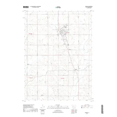
2018 Map of Audubon
USGS Topo · Published 2018About this map
Audubon serves as the central hub of this agricultural landscape in Audubon County, where the street grid is clearly defined by routes like Broadway St and Chicago St. The surrounding countryside is shaped by the winding course of the East Nishnabotna River and its many tributaries, including Bluegrass Cr and Elkhorn Cr. This topography dictated the placement of small rural settlements such as Hamlin, Nishna, and Sharon, which sit amidst a network of section-line roads. For the local historian, the map preserves the locations of several community landmarks, notably the Arlington Heights Cem and the Audubon County Airport. The distribution of burial sites like the Danish Cem and Saint Patricks Cem reflects the distinct cultural and denominational pockets that established these farming townships.
Find a feature on this map
45 named features on this map. Tap any name to fly to it.
Don’t see what you’re looking for? This feature index may not catch every label — zoom into the map to look around manually.
Map Details
Editions of this 2018 Audubon Map
This is the sole edition of this map. No revisions or reprints were ever made.
Other maps of this area

1954 · Omaha
USGS Topo · 1:250,000

1957 · Omaha
USGS Topo · 1:250,000

1957 · Audubon
USGS Topo · 1:62,500

1958 · Omaha
USGS Topo · 1:250,000

1971 · Viola Center
USGS Topo · 1:24,000

1971 · Gray
USGS Topo · 1:24,000

1978 · Elk Horn
USGS Topo · 1:24,000

1978 · Kimballton
USGS Topo · 1:24,000
1978 · Manning SE
USGS Topo · 1:24,000
1980 · Harlan
USGS Topo · 1:100,000