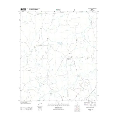
2013 Map of Augusta
USGS Topo · Published 2013About this map
The Neches River forms the eastern boundary of this landscape, where the rural settlements of Augusta and Liberty Hill anchor a network of family-named landmarks and cemeteries. In the southern portion of the quadrangle, the Bobbitt Bridge crosses over San Pedro Cr near Bobbitt Lake, serving as a focal point for local transit and history. The area is heavily defined by its small, scattered burying grounds including the Davis Family Cem, Glover Cem, and Post Oak Cem, which reflect the generations of families who established farms near the many tributaries of the Neches. Throughout the terrain, numerous creeks and branches like Silver Cr, Miles Cr, and Bodenhamer Cr drain the countryside, illustrating the complex hydrology that influenced the placement of early road networks and small hamlets like Waneta and Post Oak.
Find a feature on this map
66 named features on this map. Tap any name to fly to it.
Don’t see what you’re looking for? This feature index may not catch every label — zoom into the map to look around manually.
Map Details
Editions of this 2013 Augusta Map
This is the sole edition of this map. No revisions or reprints were ever made.
Other maps of this area

1946 · Alto
USGS Topo · 1:62,500

1950 · Crockett NE
USGS Topo · 1:24,000

1950 · Ratcliff
USGS Topo · 1:24,000

1951 · Grapeland
USGS Topo · 1:24,000

1951 · Crockett NE
USGS Topo · 1:24,000

1951 · Ratcliff
USGS Topo · 1:24,000

1952 · Slocum
USGS Topo · 1:62,500

1953 · Palestine
USGS Topo · 1:250,000

1957 · Palestine
USGS Topo · 1:250,000
1973 · Pryor Mountain
USGS Topo · 1:24,000