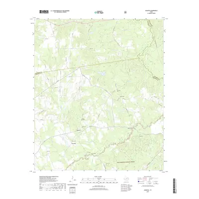
2019 Map of Augusta
USGS Topo · Published 2019About this map
Augusta and Post Oak serve as the primary focal points in this section of East Texas, where the landscape is defined by the dense woodlands of the Davy Crockett National Forest. The map reveals a deeply rooted rural community, marked by numerous family-named landmarks and resting places such as the John Sheridan Grave and the Davis Family Cem. Waterways like the Neches River, San Pedro Cr, and Hickory Hill Br carve through the terrain, with local crossings preserved at Bobbitt Bridge and Glover Bridge. The distribution of burial sites, including the Bodenhamer Cem and Wall Cem, suggests a long history of settlement near the ridges of Hickory Hill and Liberty Hill, providing a detailed record for genealogists and local historians tracking early residents of Houston and Cherokee counties.
Find a feature on this map
70 named features on this map. Tap any name to fly to it.
Don’t see what you’re looking for? This feature index may not catch every label — zoom into the map to look around manually.
Map Details
Editions of this 2019 Augusta Map
This is the sole edition of this map. No revisions or reprints were ever made.
Other maps of this area

1946 · Alto
USGS Topo · 1:62,500

1950 · Crockett NE
USGS Topo · 1:24,000

1950 · Ratcliff
USGS Topo · 1:24,000

1951 · Grapeland
USGS Topo · 1:24,000

1951 · Crockett NE
USGS Topo · 1:24,000

1951 · Ratcliff
USGS Topo · 1:24,000

1952 · Slocum
USGS Topo · 1:62,500

1953 · Palestine
USGS Topo · 1:250,000

1957 · Palestine
USGS Topo · 1:250,000
1973 · Pryor Mountain
USGS Topo · 1:24,000