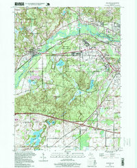
1998 Map of Augusta
USGS Topo · Published 1999About this map
The Kalamazoo River and the Battle Creek River converge near the eastern edge of this landscape, defining a region shaped by institutional history and mid-century recreation. Significant portions of the terrain are dedicated to public and federal use, most notably the Fort Custer National Cemetery and the extensive Fort Custer State Recreation Area. The map also captures the critical healthcare corridor anchored by the Veterans Administration Hospital and the American Legion Hospital, reflecting the area's role in military and veteran services.
Find a feature on this map
42 named features on this map. Tap any name to fly to it.
Don’t see what you’re looking for? This feature index may not catch every label — zoom into the map to look around manually.
Map Details
Editions of this 1998 Augusta Map
This is the sole edition of this map. No revisions or reprints were ever made.
Other maps of this area

1918 · Battle Creek
USGS Topo · 1:62,500

1918 · Union City
USGS Topo · 1:62,500

1918 · Galesburg
USGS Topo · 1:62,500

1918 · Leonidas
USGS Topo · 1:62,500

1943 · Battle Creek
USGS Topo · 1:62,500

1944 · Leonidas
USGS Topo · 1:62,500

1944 · Galesburg
USGS Topo · 1:62,500

1947 · Augusta
USGS Topo · 1:24,000

1947 · Delton
USGS Topo · 1:24,000

1947 · Galesburg
USGS Topo · 1:24,000